
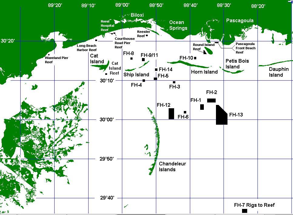
Fish Haven Map
A map showing the Fish Haven locations in the Gulf of Mexico, off the the coast of Mississippi.
Fish Haven Boundary Coordinates
A list of coordinates for the Fish Haven locations in the Gulf of Mexico, off the the coast of Mississippi.
FH-1 (MD96-00996-V): N-30°04.100' S-30°03.000' E-88°36.300' W-88°37.000'
Depth=63-68 feet; Clearance 42 feet.

FH-2 (MD96-00999-V): N-30°05.600' S-30°04.660' E-88°32.800' W-88°35.000'
Depth=54-56 feet; Clearance 30 feet.

FH-3 (MD96-01000-V): N-30°09.960' S-30°09.880' E-88°44.960' W-88°45.100'
Depth=45 feet; Clearance 30 feet.

FH-4 (MD96-01001-V): N-30°10.600' S-30°10.000' E-88°53.500' W-88°54.100'
Depth=29 feet; Clearance 23 feet.

FH-5 (MD96-01002-V): N-30°11.000' S-30°10.450' E-88°49.900' W-88°50.800'
Depth=35 feet; Clearance 25 feet.

FH-6 (MD96-01003-V): N-30°02.100' S-30°01.700' E-88°41.600' W-88°41.800'
Depth=55-75 feet; Clearance 45 feet.

FH-7 (MD96-01004-V): N-29°37.500' S-29°36.700' E-88°23.500' W-88°24.700'
Depth=125-130 feet; Clearance more than 85 feet.

FH-8 (MD96-01005-V): N-30°16.100' S-30°15.900' E-88°57.600' W-88°57.800'
Depth=15 feet; Clearance 12 feet.

FH-9/11(MD96-01006-V & MD96-01008-V): N-30°16.000' S-30°15.300'
E-88°53.600' W-88°54.300' Depth=17-18 feet; Clearance 12 feet.

FH-10 (MD96-01007-V): N-30°16.000' S-30°15.860' E-88°38.900' W-88°39.000'
Depth=9-14 feet; Clearance 7 feet.

FH-12 (MD96-01009-V): N-30°03.200' S-30°00.500' E-88°45.000' W-88°46.500'
Depth=40-45 feet; Clearance 32 feet.

FH-13 (MD96-01010-V): NE1: Lat 30°04.000' Long 88°31.700'
NE2: Lat 30°01.700' Lon 88°29.300' S-29°59.200' E-88°29.300' W-88°32.400'
Depth=65-89 feet; Clearance 63 feet.


3017.900 8836.000  12413.5547093.25-9Round Island NW
3017.150 8836.000  12413.4747090.42-9Round Island SW
3017.890 8835.890  12414.7 47093.23-9Round Island NE
3017.150 8835.400  12419.7 47090.54-9Round Island SE
3020.130 8831.940  12456.1947102.53-9Front Beach NE
3019.920 8832.060  12454.9 47101.71-9Front Beach SW
3019.900 8832.680  12448.4347101.49-9Front Beach SE
3020.030 8832.800  12447.2 47101.95-9Front Beach NW
3021.916 8853.083  12235.5547103.93-9Deer Island NW
3021.916 8852.900  12237.4647103.97-9Deer Island NE
3021.750 8852.900  12237.4747103.4 -9Deer Island SE
3021.750 8853.083  12235.5647103.34-9Deer Island SW
3022.440 8902.590  12136.1947103.44-9Court House Road Pier NW
3022.440 8902.480  12137.3347103.46-9Court House Road Pier NE
3022.360 8902.590  12136.2147103.16-9Court House Road Pier SW
3022.360 8902.480  12137.3547103.19-9Court House Road Pier SE
3020.666 8907.816  12082.1947096.17-9Long Beach Harbor NE
3020.500 8907.816  12082.2447095.61-9Long Beach Harbor SE
3020.500 8908.000  12080.3347095.57-9Long Beach Harbor SW
3020.666 8908.000  12080.2847096.13-9Long Beach Harbor NW
3022.260 8903.270  12129.1347102.66-9Naval Hospital NW
3022.310 8903.100  12130.9 47102.87-9Naval Hospital NE
3022.210 8903.100  12130.9247102.53-9Naval Hospital SE
3022.210 8903.270  12129.1447102.49-9Naval Hospital SW
3016.910 8921.920  11938.4147080.61-9Waveland Pier NW
3016.940 8921.860  11939   47080.72-9Waveland Pier NE
3016.850 8921.820  11939.4847080.43-9Waveland Pier SE
3016.830 8921.880  11938.8947080.35-9Waveland Pier SW